May 30th, 2015, a gorgeous sunrise over Bahía Magdalena, a steady cool breeze. My usual breakfast of a Jetboil full of French pressed dark coffee.


The plan was to hike from camp, near the tiny fishing village of Puerto Magdalena, to the southeastern end of Isla Magdalena and back, doing survey transects along the way in as many distinctly different habitats as I could find. It's about 12 km from where I was camping to the end of the island. A 24 km round trip is definitely doable for me *now*, after several more sessions of hiking and a completely different list of supplies and a totally revised procedure for route finding. But this time, I brought only one Nalgene of water (a little less than 1 liter, about half a gallon) and a couple sugary Cliff bars.
For one thing, I had no route plan, I imagined I would have easy hiking on level ground along the shoreline. I had no map and hadn't yet learned how to use my Garmin handheld GPS as a route planner. I had no idea how far it was to the end of the island, didn't think about time and for some reason I had it in my head that it was a little under 6 km, only half as far as it actually is. I had not yet learned, also, that in an all day hike, of course the afternoon conditions can be very different from the morning conditions, especially in spring or fall, but in Baja, really any season.
Probably most importantly, I hadn't learned from two previous experiences that I am prone to heat exhaustion, with all of its attendant miseries of extreme digestive upset, precipitous loss of fluids, disorientation and bizarre thinking. On two occasions in the past, once in the Sierra la Laguna in Baja and once in the mountains of central Arizona, I had suddenly gotten very ill with incredible diarrhea, nausea, vomiting, dizziness, inability to think clearly. On both of those occasions, I just figured that I had food poisoning or something. Neither one of those experiences happened in very extreme heat, for one thing, so I didn't really connect the dots on heat exhaustion and hyponatremia.
Anyway, it was a beautiful, cool, breezy morning, not a cloud on the horizon.

But here's how everything always goes, especially in Mexico. Of course, as already mentioned, everything is farther apart than one imagines, which makes it essential to use an actual map and be realistic. It was not possible to hike along the beach the whole way-- in fact, about a mile south of camp, I had to climb up onto an old, totally destroyed "road" that the ever-tenacious locals had tried to clear. The road would become centrally important later. For the moment, I didn't even really notice how much climbing and descending the road did along the several ridges of the island's very, very rough terrain, nor did it bother me much that, every time the road descended through a wash, it was completely blown out by severe flooding (probably from one of the many Cat 3 or 4 hurricanes that regularly blow through). These blowouts made it very slow going, descending rock walls, navigating brush filled arroyos and then finding a way back up to the road again.
So, of course, it turned into a very strenuous hike, But as those of you know who do a lot of hiking, the first few miles of a strenuous hike often don't seem that bad, especially on a beautiful cool, breezy morning, with plenty of caffeine in one's blood and the whole day ahead.

The above pic shows the terrain the "road" tried to traverse, and the steep cliffs along the impassable bay shoreline to the left. You can also get a sense of the dissected blowouts and washes as well as how incredibly rocky the terrain is. I was wearing Merrill Moabs, excellent desert hikers, but they do not have very thick soles, so they aren't the best for hiking on rocky terrain.
Anyway, by the time I got to a resting place at Punta Arena, a nice white sand beach that faces almost due east, even though in my mind it faced south, I was already pretty beat. It was almost 1 pm already-- so it had taken me 5 hours to go about 3.5 miles. I thought the end of the island was only another half mile south or so, and in fact, it was 2.5 miles, a huge difference over such terrain. I drank half my water and ate both Cliff bars.
I think I was already experiencing the early symptoms of heat stress. The weather had markedly changed, as it *always* does in Baja. The air was still now, no breeze at all, and temps were climbing. Instead of snapping to the fact that I could use the map feature of the Garmin and actually find out how far the end of the island was, I just stuck with my conviction, based on zero info, that it was "only another half mile or so." I resolved to hike that extra half mile, do some surveying and then turn around and go back to camp. I think, even if I had done this relatively sane thing, I would have been in big trouble anyway.
As my mental state deteriorated and heat exhaustion slowly set in, I "decided" to hike over land to the Pacific side of the island and imagined it would be a simple matter to hike up the Pacific coast line and then over a trail I knew that had only a slight elevation gain, back to camp. Again, with adequate supplies, adequate time, a map, advance planning including remote viewing, and a back up plan, this would have been an okay idea-- except the remote viewing would have shown me that the Pacific coast is just as impassable if not more so than the bay shoreline. Common sense would have indicated as much, of course, but as heat exhaustion sets in, common sense goes out the window.
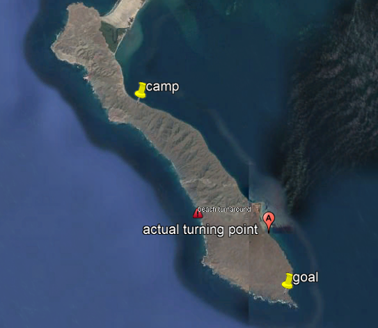
Here's a map of the island and some key markers. Camp and goal are the yellow pins. The red marker is Punta Arena, where I stopped for lunch. The exclamation point is where I finally hit the Pacific beach, at about 3 pm, after a lot of really ill advised scrambling.
From the image, the Pacific shoreline looks promising indeed, better than the trek over the rough terrain along the bay side. But about a half mile north of the marker, the shore becomes impassable, with surf pounding against steep cliffs. I was reveling in the cool sea breeze and feeling sanguine for some reason, in spite of the ever increasing hour and the fact that I had no idea what I was doing, had 1/4 gallon of water and no food. So, brilliantly, I decided to scramble up a steep canyon, with the plan being to go up and over the island, back to the bay shore, and then head back to camp along the road.
As I climbed the canyon, I experienced a couple of things that those of you who are experienced and (almost dead) hikers have experienced. One is that, with each successive climb up, I was convinced I would soon "reach the top," and yet whenever I got to a plateau, lo and behold, I was nowhere near "the top." The other reality was that the canyon was blocked from the sea breeze and the afternoon sun was full on the west facing canyon slope.
The below pic is from the Pacific beach that I finally reached after crossing over the southern part of the island. Ominous.

Ah, look! this will be an easy hike, in the cool breeze!

Up on the first plateau of the canyon I thought I could climb over to the bay side.

Back to the path over land to the bay side. This is the last pic I took.

I started to feel nauseated and shaky about halfway up the canyon. I sat in a tiny slice of shade for a while and started to panic a little bit. It *finally* dawned on me that I could be in some trouble. I settled down a little and tried to think. It still didn't occur to me to actually use the high tech GPS equipment to help figure out what to do.
I decided to climb down the canyon, head back down the Pacific coast, go back over land to the bay side, and then hike back to camp. It didn't even occur to me that it had taken me 5 hours to do the hike in the first place and it was already about 3:30, and sunset was at 7:30. I also didn't snap to the fact that I had only my sunglasses, no regular glasses, and I had no lamp or flashlight of any kind, so hiking after sunset was not the best idea.
I did scramble back down the canyon, gloried in the cool sea breeze again for a little while, but not nearly long enough, and then started trying to go back over land to the bay side. Looking back, of course I ought to have just resigned myself to sleeping near the beach and high tailing it back to camp in the morning, dehydrated but at least with a lower body temp. But I was in a low level but chronic panic and kept thinking about how I had hardly any water and no food. It felt imperative to me to get back to camp.
A short time later the first waves of crippling intestinal disorder, incredibly intense stabbing pain in the gut, pounding headache and shakes hit me, the symptoms of heat exhaustion and/or hyponatremia. Two thoughts flooded in like epiphanies: I was going to be sick again like those other two times in the past, both of which lasted for hours, and all of these times were due to heat exhaustion. It also hit me with stark reality: I could easily die out here. It was 4:30 pm. I had 3 hours to do a 5 hour hike, incapacitated periodically by the most severe gut pain, with only a quarter gallon of water and no food. Topping all of this off, I also had developed searingly painful blisters on both feet.
If I had been in my right mind, I would have just bivouacked, rode it out and I would have been all right eventually, and could have made it back at first light in the morning. But the panic grew. So I stumbled on, every now and then stopping to be sick. The vomiting quickly turned into the dry heaves-- the total food intake for the day had been two Cliff bars and a pot of coffee. In typical pennywise and pound foolish fashion, I had also taken a multivitamin. My vomit tasted like sour B vitamins for the duration.
By the time I made it back to Punta Arena, the red marker on the bay side of the above map, it was 7:00. Six hours earlier, I had set out from this locale after "lunch." The sun was already on the way down. It had taken me 2.5 hours to get across the southern end of the island. I checked my GPS, finally, and saw that I was 3.5 miles from camp. I collapsed on the road just northwest of the old whaling camp at that end of the island and was in complete despair. The excruciating stomach pain worsened with any kind of exertion, so that hiking up and down the blowouts and ditches of the road was unbearable and very slow.
And thus, dear reader, began the long and arduous and perhaps nearly fatal trek back to camp. I was obviously not in my right mind. Getting back to camp became the paramount goal. I thought it would help me to drink the last of my water, but in fact it just made me sicker. I learned later that hyponatremia and heat exhaustion are worsened by water intake without sodium. Of course, I had had only the tiniest amount of sodium all day, since coffee leaches it from the body diuretically and Cliff bars are much more carb than salt.
Addled, I stumbled up the road a short way and then became convinced that I just could not navigate the ups and downs. So I went down an arroyo to the bayside. I went along the beach for a while, stopping every now and then from extreme pain. Then I reached the first impassable segment of bay coast. I actually had to double back, go up a brush choked arroyo and then head overland. I could not find the road. The sun was down at this point and I was hiking in weak twilight, with my prescription sunglasses on and no lamp.
Quite luckily, the full moon was rising in the east. It was by moonlight that I would wend my way. I had to keep my sunglasses on though, because I was basically blind without them. I went down another arroyo to the beach, hiked the beach a little bit. I checked the GPS, remembering that I had been 3.5 miles from camp when I started back, 90 minutes earlier. Now it said I was 3.2 miles from camp. I couldn't believe it.
This sent a wave of panic through me yet again. "You better get moving. You could die out here," became a refrain in my mind repeatedly. I hiked a little ways up the beach but hit another impassable section. I tried to go up the nearest arroyo but could not even get through the brush that choked it. I had to double back down the beach again to find an arroyo I could navigate. Somehow these weird recursive miseries seemed better to me than the road.
I repeated this bizarre pattern-- heading up through an arroyo from the beach through thick brush, crossing over land a little, heading down another arroyo to the beach in the hopes that I could just hike up the coast-- about 5 times. After the 5th time, I checked the GPS again. 2.8 miles. I consoled myself by thinking "That is only as far as the run you do 3 to 4 times a week. You can do this."
One last time, I was hiking along the coast. I reached yet another set of impassable sea cliffs. I thought that just around these cliffs was clear hiking along the flat coast all the way back to camp (I was wrong). I checked the time. It was midnight. The moon was bright and cheerful in the sky. I was absolutely exhausted and despairing that I had hit yet another impassable section of bay coast.
The idea occurred to me that the water was probably not very deep, hugging the rocky shoreline along the cliffs. I could just wade around this obstacle for about 200 yards, then I would be on open beach to hike finally home. I thought about it. I looked back along the beach, knowing I had a long way to double back to a passable arroyo. I thought about climbing the nearly vertical cliff face right in front of me and going up that way, and over. It seemed impossible. It all seemed impossible.
So I started to wade. "I'll just keep going as long as I have footing and the water is no higher than my calves," I promised myself. It was going all right. The footing on the rough rock was very sure. The water was not very deep.
However, I reached an impasse even here, in the water. There seemed a short stretch ahead of me where I would have to get into deeper water before getting back to shallow water ahead. I stood and tried to figure out what to do.
The scene was high cliffs on my left, a three foot rocky shelf on which I stood, the deeper waters of the bay on my right, the surf black and roiled against the rocks and cliff bottoms, the moonlight shattering shards of silver and white off the black waves. This was one of the moments in my life where I have felt absolutely insignificant. I stood there a long time.
I finally decided to keep going, and stepped off into deeper water. It was much deeper than I thought, actually up to my chest. I went along a little bit, still with sure footing, and suddenly realized the water was close to my pack, which had cameras, gps, data, etc. I lifted my pack off and was carrying it over my head. I got up on higher rock finally and into water that was up to my calves again.
But. Directly on, in front of me, was a weird sort of passage along the front of what looked like a sea cave. Every time the waves would rush in, the cave would become completely filled and there was a sickening kind of deep, hollow "bonk." In between waves, I could clearly see an open passage in shallow water. It was like something out of a video game-- would I have enough time to go quickly across the front of the cave in between waves or would I get pushed by a wave as I was not yet clear? If I got pushed in by a wave, I was almost certain I would be completely underwater, sucked into a sea cave. I waited for several cycles of waves and noted that they were not regularly spaced. There would be no way to definitely time a crossing.
It slowly dawned on me what I had been doing this whole time. I think the cool water had begun to restore clearer thinking. Before this moment, it really had not even occurred to me how much trouble I could be in, how easy it would be to plunge into much deeper water, to be knocked over by a strong current, to be tackled by the periodic much larger wave coming in, to estimate rocky passage and water depth incorrectly wearing sunglasses in moonlight at midnight.
In spite of realizing how insane this whole thing had been, I desperately wanted to go on. I was convinced there was just open shoreline on the other side. I also didn't relish the thought of wading back through the water the 100 yards I had already come and doubling back, with soaked boots and clothes, to find an arroyo to get back up on land. It especially occurred to me that wading back through that one passage of chest deep water might be problematic. I stood there for a long time. Then I realized, without a doubt, that the tide was coming in.
That was the last deciding factor. Imagine being stuck here as the tide comes in, I thought. They'll find you floating face down someday, if they ever find you at all.
So I turned and waded back. I made it to the shore and was grateful. I looked back at where I had tried to cross and felt queasy and terrified by my own irrationality.
I tried to go up a couple of arroyos, but they were impassable. I finally doubled back what seemed like a long way and climbed up, soaking wet, with wet boots and increasingly agonizing blisters, until I was on almost level ground. Incredibly, the cold bay water had helped my condition significantly. I felt, for the first time, some relief from the stomach pains and other symptoms of heat exhaustion. The relief was so profound that I lay down on the rocky open ground, put my pack under my head, and fell asleep.
I have no idea how long I slept, but I had the strangest dream or waking auditory hallucination. A voice came out of the cool moonlit night and said, "You have a GPS. Why don't you actually use it to help you get back? Use the GPS."
I sat up and turned it on. Based on survey markers from earlier, I saw that I was only 400 meters below the road. So I gathered my strength and slowly plodded my wet booted feet up. Eventually I reached the road and lay down and slept again. Then I woke and decided to stick with the road no matter what, and that was maybe the first truly sane though I had had since about noon.
Once, when I went down one of the blowouts of the road into thick brush, I was met with the sudden high pitched and nauseating flare of a rattlesnake's rattle. I'm sure the poor snake was as startled out of sleep as I was to hear its rattle. How lucky for us they have a rattle. I hovered out of balance on a rock and was able to avoid falling forward right into where the sound was, and changed course, giving the snake a wide berth. I actually said out loud, "Seriously? Seriously?"
Periodically, I would lose the road in the moonlight, but the GPS did indeed help me find it again. I kept checking my distance and the movement toward camp was agonizingly slow.
I reached a wide, gently sloping, low flat and saw that I had finally come to where the road wound its way down to the shoreline, and knew it was open shore the rest of the way because that is how I had hiked out in the morning. This was the first moment that I actually knew I would make it back to camp. I worked my way down to the shore and only had about a mile to go. Every step on the shifting rocks, shells and sand was sharply painful.
When I finally did arrive back at camp, it was 3 am. It had taken me 8 hours to stumble my way back, mostly in moonlight, with dark sunglasses on, a long way with wet boots and wet clothes. I crawled into my tent, got undressed, got under the warm sleeping bag and gingerly took sips out of a full Osprey water bag I had left behind. The nausea had finally subsided. I had made it.
This harrowing experience taught me a lot about how to do this kind of hiking. I changed my entire preparation and planning routine. I always carry salt tablets and extra food, usually with sodium. I always carry extra water. I am prepared to bivvy if something unexpected happens. I know my route and I never deviate. I don't guess and I don't speculate. I leave my route plans for every day of field work with my friend on the peninsula who takes me to the island in his boat and with his cousin in Puerto Magdalena. I check in to Puerto Magdalena every morning and, if I don't, the agreement is that people will try to find me along the previous day's route.
I guess it took all of the above to get me to get real about the dangers of the kind of field work I do in the terrain where I do it.
It's amazing what it takes, sometimes, for us to learn.
No comments:
Post a Comment
This is an anonymous blog, mostly in an effort to respect the 12th tradition of Alcoholics Anonymous. Any identifying information in comments will result in the comment not being approved.